


Kay Mine
Project Overview
Uncovering a High-Grade Cu-Au-Zn VMS Deposit in Arizona
The Kay Mine Project is a high-grade Volcanogenic Massive Sulphide (VMS) deposit located in Yavapai County, Arizona. Defined from a depth of 60 meters to at least 900 meters, the deposit remains open at depth and along strike, presenting significant exploration upside. The project benefits from road, power, and water access across a combination of private and BLM mining claims, with no existing royalties.
Key Highlights:
High-Grade Mineral Resource - 9.2M tonnes @ 3.2% CuEq Indicated + 0.9M tonnes @ 2.4% CuEq Inferred, with potential for further expansion.
Large-Scale VMS System - Hosted in a Proterozoic-aged metamorphic belt, part of a region with over 70 known VMS deposits, several of which have seen significant historic production.
Strong Exploration Potential - Drilling has extended mineralization well beyond historic workings, with new targets identified at depth and along strike with less than 10% of prospective mineralized horizon drill-tested to-date.
Exceptional Location & Infrastructure - Situated 74 km north of Phoenix with year-round access, strong local support, and an established mining workforce.
Historical Background
The Kay Mine has a proven mining legacy dating back to the late 19th century, with historic production and extensive exploration efforts:
Pre-1900:
Small-scale mining produced approximately 635 tonnes of high-grade ore.
1918-1929:
Extensive underground development included the No. 1 Shaft (457m deep), No. 4 Shaft (366m deep), and over 11 levels of workings, though no ore was produced.
1949-1956:
Operators including Black Canyon Copper Corporation and Republic Metals Company shipped 3,016 tonnes of ore, but operations ceased after a mine collapse.
1972-1974:
Exxon Minerals conducted geophysical surveys and 8,094 meters of drilling, significantly expanding the resource model.
2018-Present:
Arizona Metals has conducted 135,000 m of drilling, geochemistry, and geophysics, outlining a deposit to at least 900m below surface
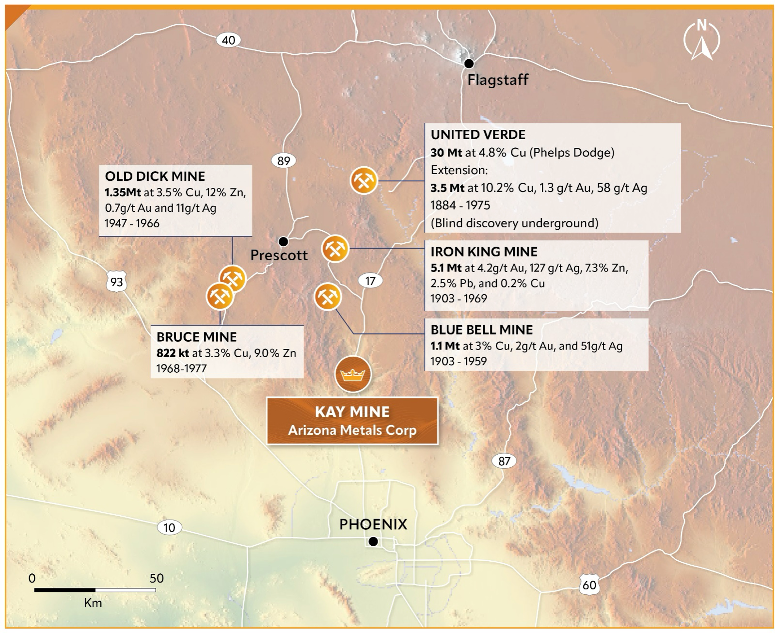
Regional Production
The Kay Mine Project is strategically positioned within one of Arizona’s most prolific VMS districts, placing it in a well-established mining jurisdiction with a rich history of high-grade production. The presence of numerous past-producing Cu-Au-Zn mines in the region not only reinforces the high-grade nature of the deposit but also provides significant geological, economic, and logistical advantages that enhance the potential for project success.
Historic District: The region contains over 70 known VMS deposits, with historic production surpassing 50 million tonnes of ore at an average grade of 3.6% Cu, amounting to approximately 3.99 billion pounds of copper.
Nearby Mines: The Kay Mine Project is surrounded by multiple past-producing Cu-Au-Zn mines, which serve as important analogs for understanding geological continuity, ore body structures, and mineralization trends.
Infrastructure & Mining-Friendly Jurisdiction: Arizona’s pro-mining regulations, skilled workforce, and established infrastructure (roads, power, and water) reduce development costs and accelerate project advancement, enhancing Kay Mine’s economic viability.
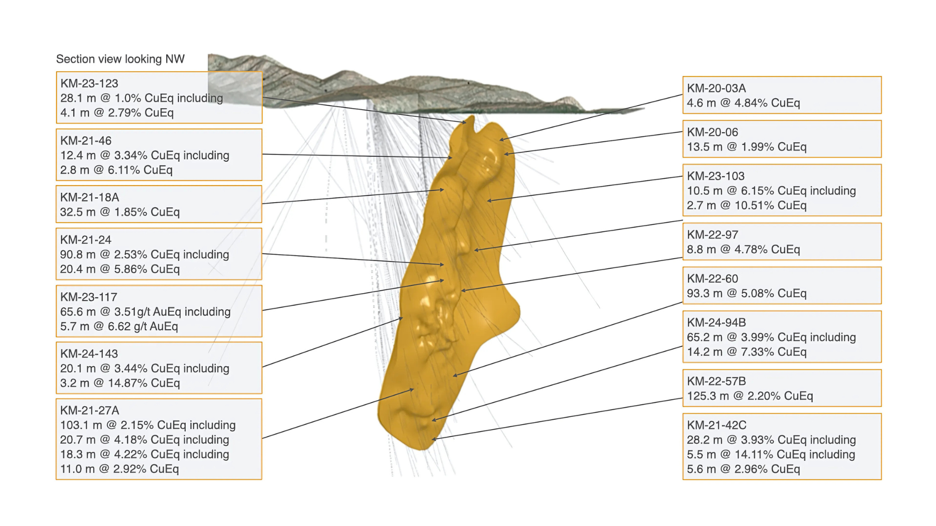
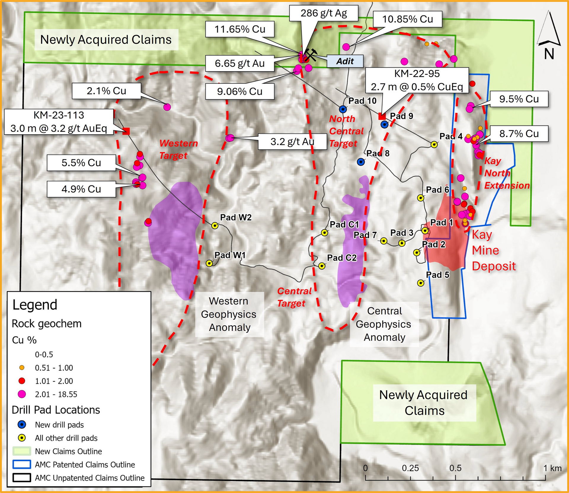
Drilling Pierce Points & Intercept Highlights
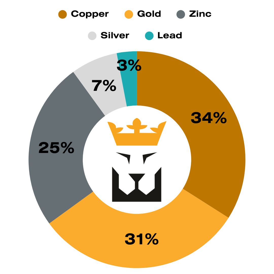
Mineral Resource Estimate (MRE)
The Kay Mine Project now boasts a significant milestone with the release of its maiden Mineral Resource Estimate (MRE) in June 2025, confirming its status as a high-grade polymetallic Volcanogenic Massive Sulphide (VMS) deposit. The resource outlines robust copper, gold, zinc, silver, and lead mineralization with excellent continuity and geometry suitable for bulk underground mining.
- Metal content was calculated using the following price assumptions: US$2,200/oz Au, US$26/oz Ag, US$4.10/lb Cu, US$1.00/lb Pb, US$1.35/lb Zn
- Metallurgical recoveries applied were: 92% Cu, 76% Pb, 85% Zn, 76% Au, 75% Ag
| Indicated Tonnes (Mt) | 9.28 | Contained Metal |
|---|---|---|
| Gold (Au) | 1.39 g/t | 415 koz |
| Silver (Ag) | 27.6 g/t | 8,253 koz |
| Copper (Cu) | 0.97% | 197.9 Mlbs |
| Lead (Pb) | 0.33% | 67.3 Mlbs |
| Zinc (Zn) | 2.39% | 490.1 Mlbs |
| CuEq | 3.18% | 650.6 Mlbs |
| Inferred Tonnes (Mt) | 0.86 | Contained Metal |
|---|---|---|
| Gold (Au) | 1.06 g/t | 29 koz |
| Silver (Ag) | 15.4 g/t | 423 koz |
| Copper (Cu) | 0.87% | 16.4 Mlbs |
| Lead (Pb) | 0.20% | 3.8 Mlbs |
| Zinc (Zn) | 1.68% | 31.8 Mlbs |
| CuEq | 2.44% | 46.1 Mlbs |
Infill Potential: The initial Mineral Resource Estimate (MRE) shows strong potential for growth through additional drilling between existing holes, which could significantly upgrade the Inferred category to Indicated.
Camp-Scale Potential: Current resources cover less than 5% of the Kay Project’s 10-kilometre strike length of prospective, folded host rocks—highlighting major untapped upside across the broader land package.
Expansion Potential: The deposit remains open for expansion along strike and at depth, offering considerable opportunity to grow the resource base beyond the boundaries of the current MRE.
* The Mineral Resource Estimate was prepared by Allan Armitage, Ph.D., P.Geo., of SGS Geological Services, an independent Qualified Person as defined by NI 43-101. Dr. Armitage conducted site visits to the Kay Mine property on October 25–26, 2023 and April 7–8, 2024. The estimate was peer reviewed by Ben Eggers, MAIG, P.Geo., also of SGS Geological Services and an independent Qualified Person under NI 43-101, who visited the property on May 30, 2025.
Expansion Potential
The Kay Mine Project presents a significant exploration upside, with multiple untested mineralized horizons and a vast strike length of 10 km. The project is located in a highly prospective VMS belt, with known mineralized zones that remain open at depth and along strike, offering numerous opportunities for expansion beyond the currently defined deposit.
Key Exploration Opportunities:
10 KM of Exploration Strike Length
- The Kay Mine deposit is structurally folded, creating multiple parallel mineralized horizons that extend over a strike length of 10 km.
- The presence of repeated stratigraphic folding increases the potential for multiple mineralized lenses, enhancing the overall prospectivity of the property.
North Central Target
- Surface sampling has returned multi-percent copper assays, with high-grade gold and anomalous zinc values.
- Strong soil anomalies suggest the presence of additional undiscovered mineralized zones.
- Drilling highlights include:
- KM-22-95: 2.7m @ 0.5% CuEq
- KM-24-153: 0.5m @ 11.34% CuEq
West Target
- Eight drill holes over a 750-meter strike length have intersected continuous mineralized horizons, confirming the presence of a new, parallel system.
- The horizon contains sphalerite, chalcopyrite, pyrite, and pyrrhotite, with highly anomalous gold, copper, and zinc values.
- Recent results include:
- KM-23-113: 3.0m @ 3.2 g/t AuEq
- Surface sampling returned up to 8.6% Cu.
Technical Reports
NI 43-101 compliant Technical Report (May 2021) for our Kay Mine project provides an in-depth analysis of geology, mineralization, and exploration potential.